A University of Maryland-led partnership will publish the first high-resolution global map of forest cover change in Science this week, providing a valuable new tool for responsible land-use management and forest conservation. By analyzing global land-use changes at a fine scale (30 meters), the study provides both sufficient detail to inform the decisions of policy makers and resource managers, and the consistency necessary to better understand the drivers of forest loss at a global scale.
This study provides the first efficient means for comparing—with a common dataset and methodology—what is happening across national borders with regard to changes in forest cover. Previously, comparing forest loss in different parts of the world required conducting expensive, individual studies in each region and each country. And without recent advances in computing technology, analysis of global satellite data would have taken years.
New methods for processing and characterizing Landsat data to map the extent of and changes in forest cover on a global scale were developed at the University of Maryland and will be disseminated through Google Earth Engine. The results will provide conservation practitioners and the public with unprecedented access to comprehensive, up-to-date information about the state of the world’s forests.
“People will use these data in ways we can’t even imagine today,” said lead author Matthew Hansen, Professor of Geographical Sciences at the University of Maryland, who headed the team of 15 university, Google and government researchers to analyze more than 10 years of Landsat satellite images.
“Brazil had used Landsat data to document its deforestation trends and to inform policy,” Hansen continued, “and they also shared their data publicly. But such data has not been widely available for other parts of the world. Our global mapping of forest cover lifts the veil—revealing what’s happening on the ground in places people could only conjecture about before.”
According to the study, the tropics were the only region to demonstrate an increase in forest loss. Despite Brazil’s well-documented progress in reducing deforestation rates over the past decade, these gains are offset by forest loss in Indonesia, Malaysia, Paraguay, Bolivia, Zambia, Angola and elsewhere. As a result, tropical forest loss is increasing by 2,101 square kilometers (811 square miles) per year.
“We have previously supported studies of the health and extent of forests at local and national scales,” said Guillermo Castilleja, Chief Program Officer for the Environmental Conservation Program at the Gordon and Betty Moore Foundation, which funded the research. “But we are also concerned with global impacts, including how changes in one region may affect deforestation and ecosystem degradation in other parts of the world.”
For the Moore Foundation, the global deforestation study represents the culmination of several different efforts over more than five years.
- The foundation formed a strategic partnership with Google in 2007 in order to strengthen Earth Engine’s capacity as a tool for environmental scientists, resource managers and policymakers.
- In December 2008, the USGS Earth Resources Observation and Science (EROS) Center made its entire Landsat archive available free of charge to users worldwide and began processing images into digital format and posting them to the Internet. A grant from the foundation in 2010 enabled more rapid processing of the 2.5 million satellite images and accelerated public availability of the archive that served as the basis for the University of Maryland’s research.
- Other grants have supported regional forest mapping efforts in geographies where the foundation has worked for the past decade, including the Amazon, Alaska, Canada and the West Coast of the United States. No prior forest mapping study supported by the foundation has been undertaken at a global scale.
“By combining the extensive Landsat database with the computing power of Google Earth Engine, Dr. Hansen saw an opportunity to do something that had never been done before,” said Rebecca Moore, who leads Google Earth Engine and Earth Outreach at Google. “To date, this is the largest-scale scientific application of Earth Engine technology to measurement and mapping of earth’s natural resources. It’s exciting to see the innovative ways in which researchers like Dr. Hansen are now using Earth Engine to scale their research globally and push the frontiers of science and conservation. We look forward to continuing our strategic partnership with the Gordon and Betty Moore Foundation in support of more such projects in the future.”
The study, entitled “High-resolution global maps of 21st-century forest cover change,” will be published in the November 15, 2013 issue of the journal Science.
The Gordon and Betty Moore Foundation believes in bold ideas that create enduring impact in the areas of science, environmental conservation and patient care. Intel co-founder Gordon and his wife Betty established the foundation to create positive change around the world and at home in the San Francisco Bay Area. Environmental conservation efforts promote sustainability, protect critical ecological systems and align conservation needs with human development. Patient care focuses on eliminating preventable harms and unnecessary healthcare costs through meaningful engagement of patients and their families in a supportive, redesigned healthcare system. Science looks for opportunities to transform–or even create–entire fields by investing in early-stage research, emerging fields and top research scientists. Visit us at Moore.org or follow @MooreEnviro.
Media contact:
Jessica Nusbaum
(650) 213-3022
jessica.nusbaum@moore.org
Learn more:
Explore the global forest change map: http://earthenginepartners.appspot.com/google.com/science-2013-global-forest
Join the live online demo and public Q&A with the researchers on Monday, November 18 at 1pm U.S. Eastern Time (10am U.S. Pacific Time):
- Submit your questions in advance via Google Moderator to get in the queue early; then vote for the questions you'd most like the research team to discuss: http://goo.gl/rhxK5X.
- Join the live-streamed event: http://goo.gl/JbWWTk
Read the study: http://www.sciencemag.org/content/342/6160/850
Images and animations:
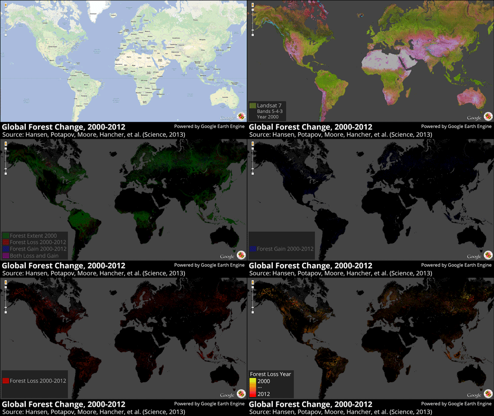
Mapping Global Forest Change: Global 30 meter resolution thematic maps of the Earth's land surface: Landsat composite reference image (2000), summary map of forest loss, extent and gain (2000-2012), individual maps of forest extent, gain, loss, and loss color-coded by year.

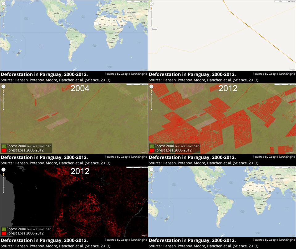
Deforestation in Paraguay, 2000-2012. The Chaco woodlands of Bolivia, Paraguay and Argentina are under intensive pressure from agroindustrial development. Paraguay's Chaco woodlands within the western half of the country are experiencing rapid deforestation in the development of cattle ranches. The result is the highest rate of deforestation in the world. 
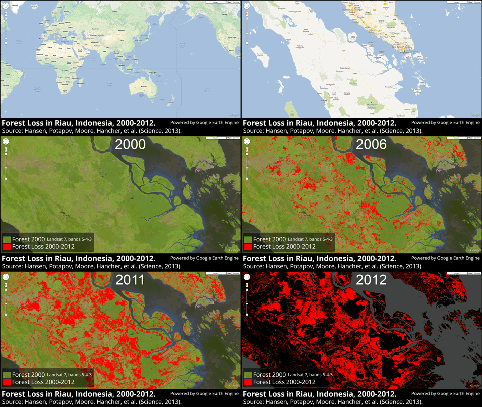
Forest loss in Riau, Indonesia, 2000-2012. Sumatra has lost over 50% of its natural forest within the past 30 years. Riau province is a global hotspot of tropical rainforest loss over the last decade, with more recent clearings moving into peatland swamps. Peatlands are home to immense soil carbon stores and unique biodiversity richness. Having nearly exhausted upland natural forest resources, agroindustrial development in Riau has moved into peatlands, with significant, deleterious environmental consequences.
