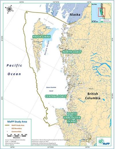
British Columbia’s Marine Planning Partnership (MaPP), a planning process co-led by the Province and 18 First Nations governments, today released signed marine plans for the northern coast of British Columbia. A significant step forward in the smart management of the Pacific coast of North America, the MaPP plans bring nearly 40,000 square miles of coastal waters under ecosystem-based management — protecting the marine environment while sustaining vibrant coastal communities whose culture and commerce depend on a healthy ocean.
A world-leading model for ocean planning
Too often, coastal waters are managed haphazardly, with multiple government agencies making independent decisions about conservation and use on a first-come, first-served basis. Ocean planning reinvents that process by inviting all relevant stakeholders to the table to make comprehensive, deliberate, and science-based decisions together about the health and use of their oceans.
The MaPP planning process stands as an unprecedented example of this type of collaborative decision-making. A range of stakeholders, including renewable energy developers, conservationists, aquaculture companies and small-boat fishermen, participated in a transparent and inclusive process. A panel of science advisors helped refine the objectives and contributed local and global marine planning expertise. Traditional knowledge and community input informed the process along with human use and ecological data.
Perhaps most importantly, the relationships and common ground forged through the planning process will provide a foundation for the partners to find solutions together to the challenges and opportunities of implementing, monitoring and enforcing the plans over time. By combining environmental and economic objectives, the MaPP plans promise to support a healthy marine environment, robust economy and strong communities in British Columbia, today and for generations to come.
Landmark achievement in ecosystem-based management
 British Columbia’s MaPP process produced four marine plans — for North Vancouver Island, Haida Gwaii, the North Coast and Central Coast — which together encompass nearly 40,000 square miles, making MaPP the largest ocean plan completed to date in North America.
British Columbia’s coastal waters include some of the world’s most productive and ecologically significant marine ecosystems, from eelgrass nurseries and estuaries to deep-sea corals. They support populations of whales and seabirds, and provide diverse habitats for salmon, rockfish, eulachon and herring.
The plans identify protection zones for these ecological treasures, special management zones for certain uses like shellfish aquaculture, and general management zones – all based on a set of ecosystem-based management principles. Together, these zones will help maintain ecosystem health, while promoting certainty for investors and helping minimize conflict among marine resource users.
The MaPP planning region and the adjacent Great Bear Rainforest will together make up the world’s largest contiguous area of land and sea operated under ecosystem-based management. (In 2006, British Columbia, First Nations and the Canadian government created land-use plans that placed 21 million acres of temperate rainforest under ecosystem-based management; galvanized a transition to a conservation-based economy based on shellfish aquaculture, renewable energy and tourism; and established carbon credits to generate revenue for land and ocean stewardship.)
The role of public-private partnership
In times of fiscal restraint, governments often look for innovative approaches to achieve their goals. The Province and First Nations governments who led the MaPP process took advantage of several creative strategies to help finance the development and implementation of their marine plans.
They invited private funders, including the Gordon and Betty Moore Foundation, to provide complementary funding for the planning process. Tides Canada served as the philanthropic and administrative home for the partnership, and the involved governments directed how all funds were spent. With the MaPP plans now in place, government funding for implementation will be complemented by private funds and potential revenue from the Great Bear carbon credits.
The First Nations and Province of British Columbia have shown tremendous vision in creating these plans to manage their marine resources, and the foundation is honored to have had the opportunity to support their planning process. The plans they have created and the process they followed now stand as a world-leading model for good oceans governance.
Read the press release from the MaPP partners here.
Related coverage:
Canadian Press
Coast Mountain News
Eagle Valley News
Vancouver Sun
- Opinion: MaPP a blueprint for marine management
- B.C., First Nations reach coastal marine pact to protect ocean health
Yale e360

Message sent
Thank you for sharing.